The app will be available in January 2024. Please register your interest now.
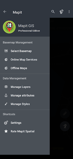
This application is a new Mapit GIS Ltd. product and a more sophisticated version of the older apps called Mapit GIS and Mapit Spatial targeting the most recent Android versions. The app has completely redesigned its data management approach as well and the mapping component updated to Mapbox SDK.
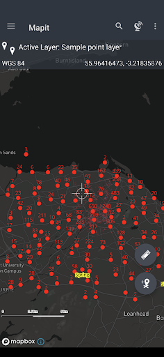
The app is providing a multi-purpose mapping solution allowing location capture and determining distance and area for the shapes drawn on the map or captured using real-time GPS tracking.
Most of the previous app's functionality is now implemented, however, some elements are currently missing and they will be added gradually in Q1 of 2024.
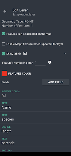
Core functionality: - a collection of spatial data in the form of POINT, LINE or POLYGON datasets, - calculation of areas, perimeters and distances. - management of the data in the form of geopackage projects - survey design - data sharing
The app is designed to be simple and light and driven by a new OGC file format for storing spatial data.
The geopackage feature layers can link their fields with the attribute set fields, so the data can be then collected using forms containing drop-down lists, multi-select lists, and barcode scanners.
The application is supporting multiple coordinate projections and you can specify your default coordinate system by providing the EPSG code in the settings - PRJ4 library is used to convert coordinates.
The application can link with high-precision GNSS systems - so you can get down to centimetre accuracy if required and take advantage of the RTK solutions provided by the leading GNSS manufacturers.
With Mapit Spatial you can capture, manage and share your data easily. Supported export and import formats: SHP File, GeoJSON, ArcJSON, KML, GPX, CSV and AutoCAD DXF.
Custom WMS, WMTS, WFS or XYZ services can be added to the software in the form of overlays. Three methods of measurement are supported in the form of GPS location, Map cursor location and Distance and bearing method.
Mapit GIS professional can be used in several applications including:
- environmental surveys, - woodland surveys, - forestry planning and woodland management surveys, - agriculture and soil types surveys, - road construction, - land surveying, - solar panel applications, - roofing and fencing, - tree surveys, - GPS and GNSS surveying, - site surveying and soil sample gathering - snow removal
GIS Software and spatial data gathering and processing are getting more and more important these days all over the world and the ability to have quick, fast and reliable workflow is becoming very important. Mapit Pro has become a day-to-day tool for thousands of people worldwide, and we hope that Mapit Spatial will improve and make your workflow more efficient and cost-effective.
We would like to address our application to everyone who is working with geographic data and is responsible for location-related tasks. There is number of science and business-related areas relying or depending on the accurate information coming from Geographic Information Systems and we hope Mapit Spatial is going to become your day-to-day tool when you are making things right out there in the field.
The app is dedicated to people working in agriculture, forestry, housing development or land survey industry, but also to customers responsible for design work in the power industry, water supply and sewage systems. We have successful customers also from the gas and oil industry, telecommunication and road engineering.
Mapit Spatial can be also adopted for any kind of spatial asset management tasks, fishery and hunting, habitat and soil mapping or other needs.